 |
Search Results |
 |
|
| New Search. | | Back to Hitlist |
show previous record show next record |
|
Voucher Data (Main Voucher, Tissue Sample or Observation) |
| Specimen/Sample Number |
2580d3e6-9390-437f-af21-c164e0e55858 |
|
Institution
(place of deposit) * |
B |
Collection * |
AlgaTerraObservation |
| Basis of Record * |
HumanObservation |
Kind of Unit * |
observation |
| Preparation Date |
|
Preparation Type |
light microscopy |
| Preparation Staff |
| Preparation Number |
|
| Preparation Materials |
|
Preparation Process |
|
Parent record | | Specimen Number/ID | D127 | Relation to parent | from same environmental sample | | Institution (place of deposit) | B | Collection | Diatom Reference Library | | Basis of Record | MaterialSample | Kind of Unit | environmental sample | | Preparation Date | | Preparation Type | water sample |
|
|
Multimedia (related to specimen/observation) | | Item | 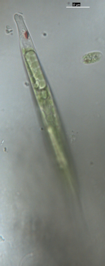 | Type | Image/Scan |
| Context | Lepocinclis acus |
Comment | |
| Creator | W.-H. Kusber |
Created (datetime) | 2016-02-08 00:00:00 |
| License | CC BY-SA 4.0 |
|
|
Preferred Identification: Lepocinclis acus (O.F.Müll.) B.Marin & Melkonian |
| phylum | Euglenophyta | | classis | Euglenophyceae |
|
| Identification Qualifier |
|
Qualifier belongs to |
|
|
| Genus |
Lepocinclis |
Subgenus |
|
| Specific Epithet |
acus |
Rank |
|
| Infraspecific Epithet |
|
Name Addendum |
|
| Breed/Cultivar |
|
| Author(s) in parenthesis |
O.F.Müll. |
Year in parenthesis |
|
| Author(s) |
B.Marin & Melkonian |
Year |
|
| Identifier |
W.-H. Kusber |
Identification Date |
|
| Kind of Identification |
det. |
Identification Notes |
|
| Preferred Identification |
Yes |
|
|
|
Gathering Details |
| Expedition/Title label |
|
Collection Method |
scraped periphyton |
| Collector(s) |
W.-H. Kusber & O. Skibbe |
Collector's No |
2016-02-08osD127 |
| Collection date from |
2016-02-08 |
Collection date to |
|
| Collection Notes |
| |
|
Geography |
| Biogeographic Region | |
Sea/Ocean | |
| Country |
Germany |
State/Province/Greater Area |
Berlin |
| Locality |
Botanic Garden Berlin, Teich Lichterfelde, Obersee |
Locality ID/Station |
|
| Slope |
|
Prevalent Aspect |
|
| Altitude Accuracy Statement |
|
Altitude from |
45
m |
| Altitude Method |
Map |
Raw data Altitude |
|
| Depth Accuracy Statement |
|
Depth from |
0.01 to 0.1
m |
| Depth Method |
|
Raw data Depth |
1 bis 10 cm Tiefe |
|
| Geodetic Datum |
WGS 84 |
Geocode Method | Map |
| Coordinates Accuracy Statement |
|
Error distance in m |
10 |
| Latitude decimal from |
52.452621 | Longitude decimal from |
13.307728 |
| Latitude decimal to |
| Longitude decimal to |
|
| Raw data Latitude |
| Raw data Longitude |
|
|
|
|
|
|
Ecological Data |
| Soil texture | |
Soil pH | |
| Habitat code | C3 - Littoral zone of inland surface waterbodies |
Land use code | |
| Habitat/Ecological aspects |
|
|
Paleontology |
| Dating Qualifier | | Series |
|
| Dating Qualifier | | Stage |
|
| Fossil Zone Name | | Formation | |
| Section Details | |
| Specimen Details | |
|
|
Other Data |
| Type |
|
Type designation |
|
| Life Stage |
|
Life Form |
|
| Sex |
|
| |
|
| Received From |
|
| Accession Number |
|
Primary Accession Name |
|
| Preservation (repeatable) |
to do | Material Consumed |
No |
| Permission Number | |
Escape Coordinates |
No |
|
Blocked for Loan Until |
|
Blocked for Loaning |
No |
|
Loan Conditions |
|
Blocked for Publishing |
No |
|
General Remarks
|
|
Internal Remarks
|
|
Dataset |
| Created by |
Wolf-Henning Kusber (2017-10-09 18:07:57) | GUID | 2580d3e6-9390-437f-af21-c164e0e55858 |
| Updated by | Wolf-Henning Kusber (2019-12-11 11:30:16) |
|
| |
|
|


